
CityLeap Frequently Asked Questions
How much will CityLeap cost?
How long might it take for CityLeap to pay for itself?
What existing City of Austin plans and goals apply to the CityLeap plan?
Most Austinites drive. Won’t CityLeap make people’s journeys longer?
Why propose bus lanes (and shared use paths) on some roadways and protected bicycle lanes (and protected intersections) on others?
Why don’t you have proposals for some arterials such as South Lamar, most of Riverside Drive, etc.?
Doesn’t CityLeap duplicate the City of Austin Corridor Program plans?
What materials will be used for the lane conversions?
What are shared use paths?
Where can I download those fantastic visuals for East MLK and South 1st and who produced them?
I have a comment/suggestion about a specific CityLeap proposal.

1. How much will CityLeap cost?
We estimate CityLeap will cost approximately $52.2m.
-
This estimate is based on the following:
141.66 [1] miles of bus lanes at $100,000 [2] per mile = $14,166,000
57.47 [3] miles of protected bike lanes at $600,000 [4] per mile = $34,482,000
[1] These are “lane mile” counts, meaning every mile of roadway equals two miles of bus lanes and shared use paths going in both directions.[2] Bus lane per mile estimate source: Best Practices In Implementing Tactical Transit Lanes, p3.
[3] This assumes two-way protected bike lanes on one side of the street. However, we hope to hear from City of Austin staff on their thoughts about whether two-way on one side or one-way on both sides should be chosen for any particular location.
[4] Protected bicycle lane per mile estimate source: Austin Bicycle Plan. Note: This estimate does not include protected intersections.
-
We estimate it would cost $230 million.
This includes 90.64 miles of shared use paths at $2 million per mile for a total of $181,280,000.
2. How long might it take for CityLeap to pay for itself?
Possibly just months!
In 2021, the City of Austin implemented a lane conversion on South Pleasant Valley Road over the Longhorn Dam, transforming one of four general purpose vehicle lanes into more space on both sides of the road for shared use paths for walking and bicycling. That project took four months to pay for itself through comprehensive crash costs to society. We might expect similar results from CityLeap.

3. What existing City of Austin plans and goals apply to the CityLeap plan?
CityLeap is compatible with direction from both Austin City Council and key City of Austin plans:
Austin City Council resolution, August 8th 2019: “Austin City Council declares a climate emergency and calls for an immediate emergency mobilization to restore a safe climate.”
Austin City Council resolution, February 15th 2024: “The City Manager is directed to solicit community input and prepare options and associated costs of capital improvements or programs that would reduce carbon emissions”
This resolution initiated the process of creating the Environmental Investment Plan to swiftly identify and fund measures to address climate change. The Joint Sustainability Committee has recommended CityLeap to be included in that plan.
Austin Strategic Mobility Plan (ASMP): Achieve a 50-50 mode share (50% drive-alone, 50% taking transit, riding a bicycle, walking, carpooling, or teleworking) by 2039.
Austin Climate Equity Plan (ACEP): “By 2030, 50% of trips in Austin are made using public transit, biking, walking, carpooling, or avoided altogether by working from home.”
While Austin has made significant progress in implementing its transportation plans, there’s rightly much doubt we’ll achieve those goals in time. We need much bolder action.

4. Most Austinites drive. Won’t CityLeap make people’s journeys longer?
Decades of evidence suggests that CityLeap will almost certainly shorten people’s journeys in Austin:
Transit, bicycles, and walking are more space-efficient. The people-moving capacity of streets with dedicated lanes for transit, bicycling, and walking is much higher. That means more people will get to where they’re going more quickly.
Those who still need to drive will experience smoother trips. With more people now taking transit or walking or bicycling, those still driving will have fewer road-users in the way.
Congestion is self-equalizing. Any temporary congestion increases will flatten out over time as people switch to non-driving transportation modes, combine trips, or travel at other times of the day.
5. Why propose bus lanes on some roadways and protected bicycle lanes on others?
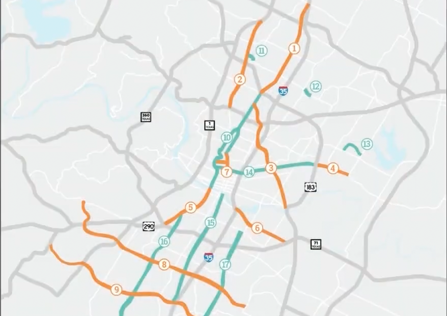
CityLeap recommends bus lanes and shared use paths for roadways with high-frequency bus lines and protected bike lanes (and protected intersections) for roadways with low frequency or no bus lines. See here for a detailed breakdown of recommendations for every arterial.
However, there may be reasons, such as existing City plans, to divert from our recommendations on any given facility. Therefore, City of Austin staff may need to weigh in on the optimal solution for each location.
6. Why don’t you have proposals for some arterials such as South Lamar, most of Riverside Drive, etc.?
CityLeap excludes a small number of arterials because such roadways are owned by the State of Texas and don’t fall under City of Austin jurisdiction or because those roadways are covered under existing plans such as Project Connect and the City of Austin Corridor Program.
7. Doesn’t CityLeap duplicate the City of Austin Corridor Program plans?
No, for these reasons:
The Corridor Program only addresses nine arterials (Airport, Burnet, E. Riverside, E. MLK Jr, Guadalupe, N. Lamar, Slaughter, S. Lamar, and William Cannon.) CityLeap addresses all arterial roadways.
Most of the plans for those corridors don’t involve road lane conversions.
The plans under Corridor Program were conceived the best part of ten years ago. Since then, with accelerations in climate change and public support for alternatives to driving, the environmental and political reality has changed. It’s time to be much bolder than those plans were.

8. What materials will be used for the lane conversions?
CityLeap recommends inexpensive “quick build” materials where possible, including paint for bus lanes and a combination of “armadillos”, flex posts, and paint for protected bike lanes and protected intersections.
However, shared use paths will require heavier-duty materials and more expensive, involved work.

9. What are shared use paths?
Shared use paths (SUPs) are paved paths for both walking and bicycling. SUPs usually look like wide sidewalks and are typically 10’ or wider. We’ve used the alternative term “bicycle-pedestrian path” on the CityLeap website.
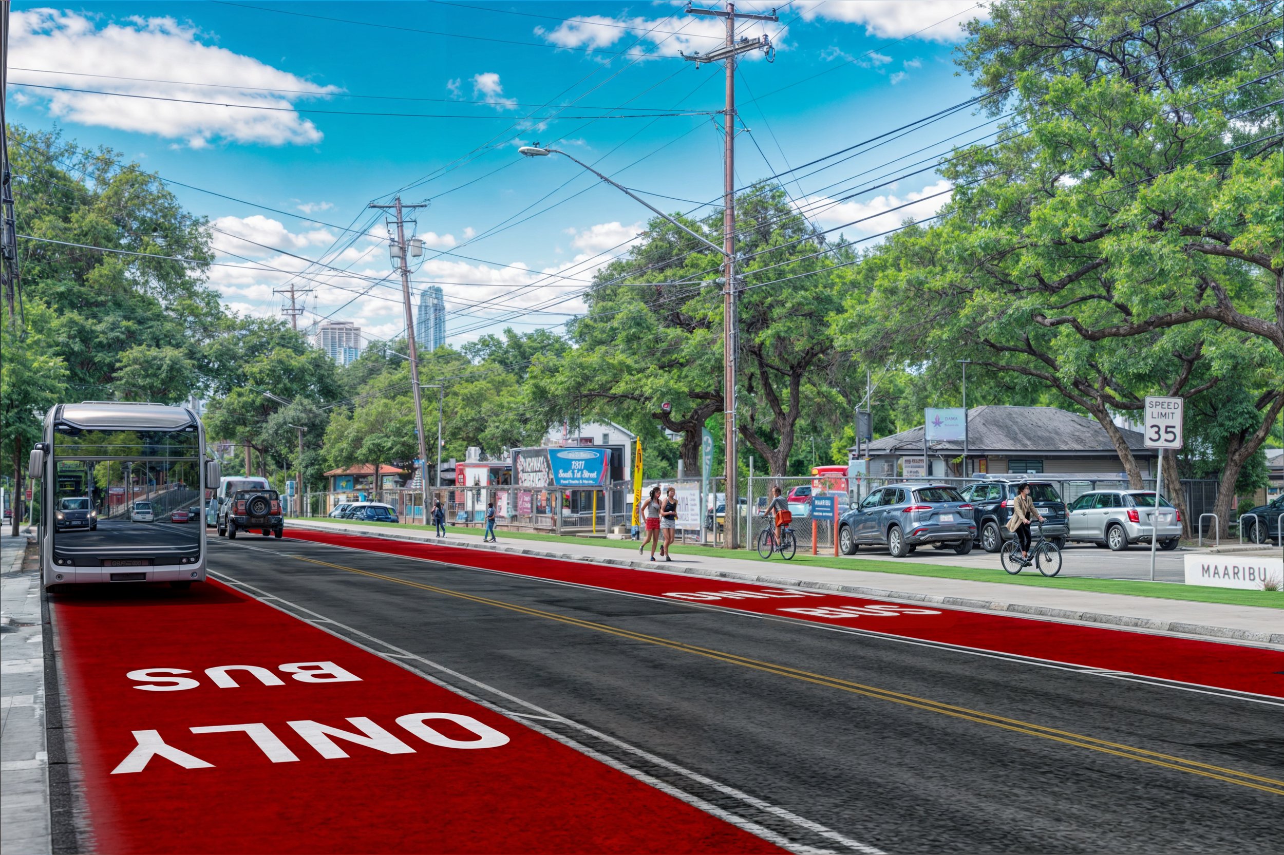
10. Where can I download those fantastic visuals for East MLK and South 1st and who produced them?
You can download the before and after visuals, along with other visual assets, here.
Safe Streets Austin supporter Garett Hopper made these excellent visuals. Contact Garett at garett@hoppervisuals.com or follow him on Instagram.

11. I have a comment/suggestion about a specific CityLeap proposal.
Have we missed a City of Austin-owned arterial in our network map? Do you have a different proposal for a lane conversion on any given roadway?
For these and other questions/comments, email us at info@safestreetsaustin.org.
Thank you for your interest in CityLeap!
We hope you will support this important plan.